MODULE 10 – Plate Tectonics
June 24, 2009.
Refer to pp. 247-277, Chapter 9, in the Prentice Hall Earth Science Book for background information during this module.
Lesson 10.01 – Continental Drift
Standards: ES3.a Students know features of the ocean floor (magnetic patterns, age, and sea-floor topography) provide evidence of plate tectonics.
ES3.b Students know the principal structures that form at the three different kinds of plate boundaries.
ES3.c Students know how to explain the properties of rocks based on the physical and chemical conditions in which they formed, including plate tectonic processes.
INTRODUCTION
Will California eventually slide into the ocean? Have continents really drifted apart over the centuries? After completing this module, you will be able the answer these questions and many others.
Early in the twentieth century, most geologists thought that the positions of the ocean basins and continents were fixed. During the last few decades, however, new data have dramatically changed our understanding of how Earth works.
INSTRUCTION
An Idea Before Its Time
The idea that continents fit together like pieces of a jigsaw puzzle came about when better world maps became available. Figure 1 shows the two most obvious pieces of this jigsaw puzzle. However, little significance was given this idea until 1915, when Alfred Wegener, a German scientist, proposed his radical hypothesis of continental drift. Wegener’s continental drift hypothesis stated that the continents had once been joined to form a single supercontinent. He called this supercontinent Pangaea, meaning all land.
Wegener also hypothesized that about 200 million years ago Pangaea began breaking into smaller continents. These continents then drifted to their present positions, as shown on page 250. Wegener and others collected much evidence to support these claims. Let’s examine their evidence.
Click here (http://www.pearsonsuccessnet.com/ebook/products/0-13-125909-1/view1_hses_ch09_p0250.pdf) to see how the supercontinent split up into the continents of today.
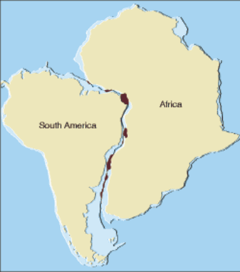
Figure 1 A Curious Fit This map shows the best fit of South America and Africa at a depth of about 900 meters. The areas where continents overlap appear in brown. Inferring Why are there areas of overlap?
Evidence: The Continental Puzzle
Wegener first thought that the continents might have been joined when he noticed the similarity between the coastlines on opposite sides of the South Atlantic Ocean. He used present-day shorelines to show how the continents fit together. However, his opponents correctly argued that erosion continually changes shorelines over time.
A When all the continents were together, there must also have been one huge ocean surrounding them. This ocean is called Panthalassa (pan = all, thalassa = sea). Today all that remains of Panthalassa is the Pacific Ocean, which has been decreasing in size since the breakup of Pangaea.
Evidence: Matching Fossils
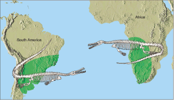 Fossil evidence for continental drift includes several fossil organisms found on different landmasses. Wegener reasoned that these organisms could not have crossed the vast oceans presently separating the continents. An example is Mesosaurus, an aquatic reptile whose fossil remains are limited to eastern South America and southern Africa, as shown in Figure 2. If Mesosaurus had been able to swim well enough to cross the vast South Atlantic Ocean, its fossils should be more widely distributed. This is not the case. Therefore, Wegener argued, South America and Africa must have been joined somehow.
The idea of land bridges was once the most widely accepted explanation for similar fossils being found on different landmasses. Most scientists believed that during a recent glacial period, the lowering of sea level allowed animals to cross the narrow Bering Strait between Asia and North America. However, if land bridges did exist between South America and Africa, their remnants should still lie below sea level. But no signs of such land bridges have ever been found in the Atlantic Ocean.
Figure 2 Location of Mesosaurus Fossils of Mesosaurus have been found on both sides of the South Atlantic and nowhere else in the world. Fossil remains of this and other organisms on the continents of Africa and South America appear to link these landmasses at some time in Earth’s history.
Evidence: Rock Types and Structures
Anyone who has worked a jigsaw puzzle knows that the pieces must fit together to form a clear picture. The clear picture in the continental drift puzzle is one of matching rock types and mountain belts. If the continents existed as Pangaea, the rocks found in a particular region on one continent should closely match in age and type those in adjacent positions on the adjoining continent.
Rock evidence for continental drift exists in the form of several mountain belts that end at one coastline, only to reappear on a landmass across the ocean. For example, the Appalachian mountain belt runs northeastward through the eastern United States, ending off the coast of Newfoundland, as shown in Figure 4A. Mountains of the same age with similar rocks and structures are found in the British Isles and Scandinavia. When these landmasses are fit together as in Figure 4B, the mountain chains form a nearly continuous belt.
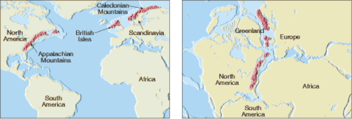
Figure 4 A The Appalachian Mountains run along the eastern side of North America and disappear off the coast of Newfoundland. Mountains that are similar in age and structure are found in the British Isles and Scandinavia. B When these landmasses are united as Pangaea, these ancient mountain chains form a nearly continuous belt.
Wegener was a meteorologist, so he was interested in obtaining data about ancient climates to support continental drift. And he did find evidence for dramatic global climate changes. Wegener found glacial deposits showing that between 220 million and 300 million years ago, ice sheets covered large areas of the Southern Hemisphere. Layers of glacial till were found in southern Africa and South America, as well as in India and Australia. Below these beds of glacial debris lay scratched and grooved bedrock carved by the ice. In some locations, the scratches and grooves showed that the ice had moved from what is now the sea onto land. It is unusual for large continental glaciers to move from the sea onto land. It is also interesting that much of the land area that shows evidence of this glaciation now lies near the equator in a subtropical or tropical climate.
Could Earth have been cold enough to allow the formation of continental glaciers in what is now a tropical region? Wegener rejected this idea because, during this same time period, large tropical swamps existed in the Northern Hemisphere. The lush vegetation of these swamps eventually became the major coal fields of the eastern United States, Europe, and Siberia.
Wegener thought there was a better explanation for the ancient climate evidence he observed. Thinking of the landmasses as a supercontinent, with South Africa centered over the South Pole, would create the conditions necessary to form large areas of glacial ice over much of the Southern Hemisphere. The supercontinent idea would also place the northern landmasses nearer the tropics and account for their vast coal deposits, as shown in Figure 5.

Figure 5 A The area of Pangaea covered by glacial ice 300 million years ago. B The continents as they are today. The white areas indicate where evidence of the old ice sheets exists. Interpreting Diagrams Where were the continents located when the glaciers formed?
Rejecting a Hypothesis
Wegener’s drift hypothesis faced a great deal of criticism from other scientists. One objection was that Wegener could not describe a mechanism that was capable of moving the continents across the globe. Wegener proposed that the tidal influence of the Moon was strong enough to give the continents a westward motion. However, physicists quickly responded that tidal friction of the size needed to move the continents would stop Earth’s rotation.
Wegener also proposed that the larger and sturdier continents broke through the oceanic crust, much like ice breakers cut through ice. However, no evidence existed to suggest that the ocean floor was weak enough to permit passage of the continents without the ocean floors being broken and deformed in the process.
Most scientists in Wegener’s day rejected his hypothesis. However, a few geologists continued to search for additional evidence of continents in motion.

Figure 6 Mountain ranges are commonly formed at plate boundaries. This photograph shows part of the Canadian Rockies in Banff National Park, Alberta, Canada.
A New Theory Emerges
During the years that followed Wegener’s hypothesis, major strides in technology enabled scientists to map the ocean floor. Extensive data on earthquake activity and Earth’s magnetic field also became available. By 1968, these findings led to a new theory, known as plate tectonics. This theory provides the framework for understanding most geologic processes, such as the formation of the mountains shown in Figure 6.
PRACTICE
1. Take notes on the above information.
2. Click here (http://www.teachersdomain.org/asset/ess05_vid_wegener1/) to watch a video about Continental Drift.
3. Click here (http://www.teachersdomain.org/asset/lsps07_int_biogeography/) to do an interactive activity about Continental Drift.
ASSESSMENT
4. Turn in your notes.
5. Take the Lesson 10-01 Quiz in Quia.
Comments (0)
You don't have permission to comment on this page.