MODULE 9 – Geologic Time & Maps
(Refer to Chapter 12 in the Prentice Hall Earth Science Book for background information during this module.)
Lesson 9.01 – Earth’s History
Standards:
IE1.d Formulate explanations by using logic and evidence.
1. c. Students know the evidence from geological studies of Earth and other planets suggests that the early Earth was very different from Earth today. (Chapter 12 Section 1)
INTRODUCTION
In the 18th and 19th centuries, scientists recognized that Earth had a very long history and that Earth’s physical features must have taken a long time to form. But they had no way of knowing Earth’s true age. A geologic time scale was developed that showed the sequence, or order, of events based on several principles of relative dating. What are these principles? What part do fossils play? In this chapter you will learn the answers to these questions.
INSTRUCTION
Rocks Record Earth History
In 1869, Major John Wesley Powell, shown in Figure 1A, led an expedition down the Colorado River and through the Grand Canyon, shown in Figure 1B. Powell realized that the evidence for an ancient Earth was concealed in its rocks. Powell was impressed with the record of Earth’s history contained in the rocks exposed along the walls of the Grand Canyon.

Figure 1 Exploring the Grand Canyon A John Wesley Powell, pioneering geologist and the second director of the U.S. Geological Survey. B Start of the expedition from Green River station.
 Rocks record geological events and changing life forms of the past. Erosion has removed a lot of Earth’s rock record but enough of it remains to allow much of the story to be studied and interpreted.
Geological events by themselves, however, have little meaning until they are put into a time perspective. The geologic time scale revolutionized the way people think about time and how they perceive our planet. We have learned that Earth is much older than anyone had previously imagined and that its surface and interior have been changed by the same geological processes that continue today.
A Brief History of Geology
The primary goal of geologists is to interpret Earth’s history. By studying rocks, especially sedimentary rocks, geologists can begin to understand and explain the past.
In the mid-1600s, Archbishop James Ussher constructed a chronology or time line of both human and Earth history in which he determined that Earth was more than five thousand years old. He believed Earth had been created in 4004 b.c. Ussher published his chronology, and his book earned widespread acceptance among Europe’s scientific and religious leaders.
In the late 1700s, James Hutton, a Scottish physician and gentleman farmer, published his Theory of the Earth. In this work, Hutton put forth the fundamental principle of uniformitarianism, which simply states that the physical, chemical, and biological laws that operate today have also operated in the geologic past. Uniformitarianism means that the forces and processes that we observe today have been at work for a very long time. To understand the geologic past, we must first understand present-day processes and their results.
Today, scientists understand that these same processes may not always have had the same relative importance or operated at precisely the same rate. Moreover, some important geologic processes are not currently observable, but evidence that they occur is well established. For example, we know that Earth has been hit by large meteorites even though we have no human witnesses. Such events altered Earth’s crust, modified its climate, and strongly influenced life on the planet.
The acceptance of uniformitarianism meant the acceptance of a very long history for Earth. It is important to remember that although many features of our physical landscape may seem to be unchanging over our lifetimes, they are still changing, but on time scales of hundreds, thousands, or even millions of years.
Relative Dating—Key Principles
During the late 1800s and early 1900s, several attempts were made to determine the age of Earth. To establish a relative time scale, a few basic principles or rules had to be discovered and applied. These principles were major breakthroughs in thinking at the time, and their discovery and acceptance was an important scientific achievement.
Relative dating means identifying which rock units formed first, second, third, and so on. Relative dating tells us the sequence in which events occurred, not how long ago they occurred.
Law of Superposition
Nicolaus Steno, a Danish anatomist, geologist, and priest (1636–1686), is credited with describing a set of geologic observations that are the basis of relative dating. The first observation is the law of superposition. The law of superposition states that in an undeformed sequence of sedimentary rocks, each bed is older than the one above it and younger than the one below it. Although it may seem obvious that a rock layer could not be deposited unless it had something older beneath it for support, it was not until 1669 that Steno stated the principle. This rule also applies to other surface-deposited materials, such as lava flows and beds of ash from volcanic eruptions. Applying the law of superposition to the beds exposed in the upper portion of the Grand Canyon, shown in Figure 2, you can easily place the layers in their proper order.
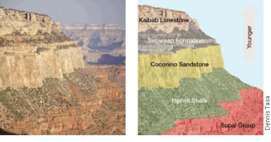 Figure 2 Ordering the Grand Canyon’s History The law of superposition can be applied to the layers exposed in the Grand Canyon. Interpreting Illustrations Which layer is the oldest? youngest?
Principle of Original Horizontality
 Another of Steno’s observations is called the principle of original horizontality. The principle of original horizontality means that layers of sediment are generally deposited in a horizontal position. If you see rock layers that are flat, it means they haven’t been disturbed and they still are in their original horizontal position. The layers in the Grand Canyon shown on pages 334–335 and in Figure 2 clearly demonstrate this. However, the rock layers shown in Figure 3 have been tilted and bent. This tilting means they must have been moved into this position sometime after their deposition.
Figure 3 Disturbed Rock Layers Rock layers that are folded or tilted must have been moved into that position by crustal disturbances after their deposition. These folded layers are exposed in the Namib Desert (southwestern Africa).
Principle of Cross-Cutting Relationships
The principle of cross-cutting relationships is Steno’s third observation. The principle of cross-cutting relationships states that when a fault cuts through, or when magma intrudes other rocks and crystallizes, we can assume that the fault or intrusion is younger than the rocks affected. For example, in Figure 4 you can see that fault A occurred after the sandstone layer was deposited because it “broke” the layer. However, fault A occurred before the conglomerate was laid down, because that layer is unbroken. Because they cut through the layers of sedimentary rock, the faults and dikes clearly must have occurred after the sedimentary layers were deposited.
 Figure 4 Applying Steno’s Principles Cross-cutting relationships are an important principle used in relative dating. An intrusive rock body is younger than the rocks it intrudes. A fault is younger than the rock layers it cuts. Interpreting Diagrams What is the age relationship between the batholith, dike B, dike A, and the sill?
Inclusions
 Sometimes inclusions can help the relative dating process. Inclusions are pieces of one rock unit that are contained within another. The rock unit next to the one containing the inclusions must have been there first in order to provide the rock fragments. Therefore, the rock unit containing inclusions is the younger of the two.
Figure 5 provides an example. The photograph in Figure 5C shows inclusions of igneous rock within a layer of sedimentary rock. How did they get there? The inclusions indicate that the sedimentary layer was deposited on top of the weathered igneous mass. The sedimentary layer must be younger than the igneous rock because the sedimentary layer contains pieces of the igneous rock. We know the layer was not intruded upon by magma from below that later crystallized because the sedimentary rock is still horizontal.
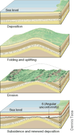 Figure 5 A A mass of igneous rock formed from magma that intruded an older rock body. B The older rock erodes and exposes the igneous rock to weathering. C Sedimentary rock layers form on top of the weathered igneous rock.
Unconformities
Casual observation of layers of rock may look like they represent a complete geologic history of an area. However, no place on Earth is geologically complete. Throughout Earth’s history, the deposition of sediment has been interrupted again and again. All such breaks in the rock record are termed unconformities. An unconformity represents a long period during which deposition stopped, erosion removed previously formed rocks, and then deposition resumed. In each case uplift and erosion are followed by subsidence and renewed sedimentation, as shown in Figure 6. Unconformities are important features because they represent significant geologic events in Earth history. Moreover, their recognition helps us identify what intervals of time are not represented in the rock record.
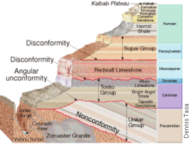 Figure 6 Formation of an Angular Conformity An angular unconformity represents an extended period during which deformation and erosion occurred.
A geologic cross section of the Grand Canyon is shown in Figure 7. It shows the three basic types of unconformities: angular unconformities, disconformities, and nonconformities. Perhaps the most easily recognized unconformity is an angular unconformity. It appears as tilted or folded sedimentary rocks that are overlain by younger, more flat-lying strata. An angular unconformity indicates that during the pause in deposition, a period of deformation (folding or tilting) and erosion occurred.
Figure 7 A Record of Uplift, Erosion, and Deposition This cross section through the Grand Canyon illustrates the three basic types of unconformities.
Two sedimentary rock layers that are separated by an erosional surface are called a disconformity. Disconformities are more common than angular unconformities, but they are more difficult to recognize. The third basic type of unconformity is a nonconformity. Nonconformities mean the erosional surface separates older metamorphic or intrusive igneous rocks from younger sedimentary rocks.
PRACTICE
1. Take notes on the above information.
2. Click here (http://www.teachersdomain.org/asset/ess05_vid_canyon/) to view a video about how the Grand Canyon was formed.
3. Click here (http://www.teachersdomain.org/asset/ess05_vid_footprint/) to view a video about the top two layers of the Grand Canyon.
ASSESSMENT
1. Turn in your notes.
2. Take the Lesson 9-01 Quiz in Quia.